Photo: Konstantinos Eleftheriadis, NCSR Demokritos
Linking the Ny-Ålesund research station observatories – an effort to solve the Arctic climate change riddle
By: Konstantinos Eleftheriadis, NCSR Demokritos, Greece and the ReHearsol team
A team of researchers studying the footprint of short lived climate forcers in the Arctic has started connecting data from multiple measurements sites around Ny-Ålesund including in-situ and remote sensing methods. Part of that was recently conducted in a form of a short field campaign; a long awaited come back in the wake of the COVID-19 pandemic.
The complex role of short lived aerosol species in the arctic atmosphere and their direct and indirect effect on the radiative budget is a continuing area of uncertainty for current polar research
The background
Although the Arctic in general is assumed as a relatively clean region with limited influence from the densely populated areas of the Northern hemisphere, the history of Arctic pollution observations tells a different story. Anecdotal observations of atmospheric pollution date back several hundred years, but the term “Arctic haze” was introduced in the 1950s by J. Murray Mitchell to describe the haze layer observed in the American Arctic.
In the 1970s, it could be established that this phenomenon was caused by long-range transported pollution in late winter when favourable transport pathways and scarce removal mechanisms lead to an enhancement of the pollutants arriving in gaseous form as well as small particles in the micrometer and nanometer size range, which we call aerosols. This led to establishing the European Monitoring and Evaluation Programme (EMEP) including the northern most observatory at Zeppelin Mountain in Ny-Ålesund in 1979. Regulations on pollution emissions led to significant reductions in observed anthropogenic pollutants. On the other hand, biomass burning has surged, especially due to boreal forest fires in both Eurasia and North America, in recent years. There is a mix of natural and anthropogenic sources and on-going process in the atmospheric column that affect also the way aerosol particles interact with solar and infrared radiation, change the optical properties of snow when they deposit on the surface and modify the lifetime and nature of clouds.
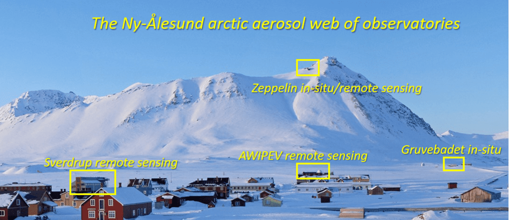
Ny-Ålesund is currently blessed with a long term record of observations at several locations
While the early air-quality stations measured in-situ pollution levels by direct air sampling, measurements of aerosol optical depth (AOD) by means of sun photometers provide information about the total extinction of aerosols in the atmospheric column. This is of great importance for investigations of long-range pollution transport, mostly occurring in the free troposphere. Although there is extensive collaboration and exchange between groups who have developed the various instruments in use, there are different routines both regarding data quality control and cloud flagging and regarding data aggregation routines. This causes challenges when comparing or integrating various data sets in order to achieve as complete time series as possible for individual sites of regions.
The important anthropogenic pollutant Black Carbon is also an agent of choise to connect in –situ observations with instruments measuring aerosols in the ground and remote sensing instruments measuring AOD. Harmonization of such measurements and connecting the pieces of the puzzle is what the ReHearsol project is trying to do.
How it all started at a Svalbard Science Conference in Oslo
This project evolved out of networking activity during the Svalbard Science Conference 2019 at Fornebu and during discussions on how to make progress in developing the SIOS Data Management System as a common tool of sharing relevant data in a wider community. While activities in the Ny-Ålesund Atmospheric Flagship programme are mostly science-driven, and SIOS activities still heavily depend on national funding processes, this project opens a space of opportunity to enhance, improve and integrate both historical data sets, ongoing observation programs and the emerging activities in a very practical frame, with SIOS as the natural vehicle of integration.
The project involves scientists from 7 countries with a long history record in aerosol measurements with focus in the Arctic and mainly Svalbard.
Project partners and lead scientists
- Georg H. Hansen, NILU, Norway (Project manager)
- Natalia Kouremeti and Stelios Kazadzis, PMOD/World Radiation Centre, Switzerland
- Christoph Ritter, Alfred-Wegener-Institut, Germany
- Mauro Mazzola and Vito Vitale, National research Centre (CNR), Italy
- Tymon Zielinski, Institute of Oceanology, Poland
- David Mateos, University of Valladolid, Spain
- Konstantinos Eleftheriadis, NCSR Demokritos, Greece
Project objectives
The main aim of this project is to revisit all AOD measurements performed so far in and around Svalbard in order to establish an optimized set of data both with a high time resolution and aggregated data sets, and make these data available through the SIOS Data Management System (SDMS).
In more detail, and more related to Ny-Aalesund, the work will:
- Collect all AOD observations performed in Ny-Ålesund, Hornsund, possibly Barentsburg, and offshore so far;
- Systematically compare datasets from Ny-Ålesund village performed simultaneously at the highest possible time resolution; including new Ny-Ålesund AOD measurements (Cimel at AWIPEV, NILU Pandora at NPI-Sverdrup)
- Establish a unified AOD dataset for Ny-Ålesund by homogenizing AOD datasets (assessing calibration and retrieval differences among different instruments) and report on the uncertainty of the unified dataset;
- Compare and establish a link between Ny-Ålesund and Gruvebadet sea level observations with higher altitude Zeppelin Observatory data, including both AOD and in-situ black carbon absorption measurements;
The last activity of the project is to look at the first few hundred meters of the atmosphere and investigate the similarity or differences between two of the in-situ datasets for aerosols and Black Carbon at Zeppelin and Gruvebadet. This included an extra step a small campaign with portable instruments measuring the above parameters at the two observatories and also in between.

View of Gruvebadet Observatory at 30 m elevation as seen from the cable car. The non-conventional weapon of choice allowing measurements between the two observatories located at different altitudes between approximately 50 and 475 meters was the cable car, which transports scientists and cargo to the Zeppelin observatory
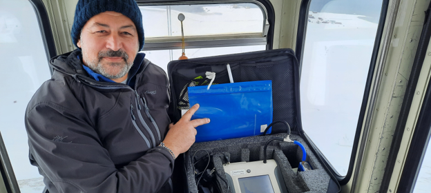
Konstantinos Eleftheriadis, NCSR Demokritos, Greece, daily routine of at least two trips per day up and down the mountain with the portable set of instruments collecting data during the 12 minute trip.
Did you find what you were looking for?